Stoneline
(This chapter was contributed by Prof. Horst Fölster, Göttingen)
-
Stone line is indicating a lithological discontinuity in the
soil, e.g. between saprolite and a slope sediment. They mark a former erosion
surface which has been covered by a slope sediment. The term slope sediment
shall stress the fact that slopes not only are the localities of erosion but
also of sedimentation. It is a layer (a few cm thick) of angular gravel. The
form of the stones are angular to rounded.
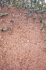 |
| Fig.1 Stoneline, Ghana |
| (
Source: Prof. Horst Fölster, Göttingen.) |
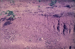 |
| Fig.2 Nigeria; “double-discontinuity” of hillwash
over gravel over saprolith. The last boundary (Grenze) of gravel over saprolith
is marked by a stoneline. |
| (
Source: Prof. Horst Fölster, Göttingen.) |
-
The relation between erosion and sedimentation is shown in
Graph A,B, C:
 |
| Fig.3 Climatic phase changes and their geomorphic
consequences |
| (
Source: Prof. Horst Fölster, Göttingen.) |
-
Erosion occurs when run off is high, e.g. on man-made
disturbance (cultivation) but also under natural conditions during climatic
phases of lower rainfall which renders the vegetation open. Such climatic
phases of unstability have occurred again and again, usually separated by
climatic phases of higher rainfall with stable, dense vegetation and low run
off (stable phases).
-
Surface run off concentrates, provokes rills (shallower or
deeper gullies). The inclination of the rill bottoms is regulated by the amount
of run off , the slope angle and the water level in the valley, and it decides
on the level of the erosion surface.
-
The old soil mantle above the new erosion surface is
mobilised along the scarpes on the back and the sides of the rills. Elements
too heavy to be transported away from the scarp, fall down and remain on the
new erosion surface. This is the stone line in a narrower sense (sensu
strictu). The remaining material may reach the valley but may also be
deposited, like in Graph under A (in this case a ferruginous gravel). This is
called intermittent transport, and is caused by varying rain intensities.
Intermittent gravelly deposits are more frequently found in the soil mantle in
regions with weakly inclined slopes because of the reduced transport power of
the run off.
-
When climate turns more humid, the vegetation denser, and the
run off lower, only finer material can be mobilised and be transported (B in
the graph). In this way two layers of slope sediment can develop (above the
proper stone line) during the cause of one unstable phase.
-
The situation in the soil mantle may become more complicated
when a second unstable phase intervenes, like in C of the graph. In this case
it was a minor instability which only eroded the valley part and sent a few
rills upslope. They were later filled with a fine grained sandy
deposit.
|
 previous | next

