Vertisols
Table of contents
-
Introduction
-
Parent material and environment
-
Regional Distribution
-
Definition
-
Genesis
a. Formation of smectite-rich parent material
b. Formation of a vertic horizon
-
Characteristics of Vertisols
a. Morphological characteristics
b. Chemical characteristics
c. Physical characteristics
-
Management and Use of Vertisols
1. Introduction
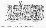
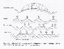
 |
| Fig.1 The vertic structure of Vertisols |
| (
Source: FAO, 2001.) |
-
The name Vertisols comes from the Latin word vertere = to
turn.
-
Vertisols belong to the Reference Soil Groups set #3 of the
WRB reference system. This set includes mineral soils whose formation is
conditioned by the particular properties of their parent material (World Soil
Resources Report 94, 2001).
-
Vertisols contain a high content of expanding 2:1 lattice
clays which exhibit swelling and shrinking features upon wetting and drying,
leading to the characteristic phenomena as slickenside formation, the formation
of deep wide cracks from the surface downward upon drying and sometimes
undulating microtopography
(
 gilgai)
. gilgai)
.
-
They are internationally known as:
-
Vertisols, black cotton soils: Soil Taxonomy,
USA
-
Gilgai: Australia
-
Regur: India
2. Parent material and environment
Parent material:
-
The type of parent material is the most important factor
involved in the formation and distribution of Vertisols. The soil materials on
which Vertisols form need to have the minimum clay content and the smectitic
type of clay.
-
The parent materials may originate from sediments or igneous
or metamorphic origins. Most Vertisols form on weathering products of basic
and/or
 ultrabasic
rocks or on sediments with high amounts of
smectites. ultrabasic
rocks or on sediments with high amounts of
smectites.
-
Examples of sedimentary origin are: loessial, fluvial,
colluvial, lacustrine and marine deposits, and marl, chalk, limestone, coral
and shale bedrock.
-
Igneous and metamorphic origins refer to Vertisols developed
from weathering products of volcanic ash and tuff, schist, granite, gneiss,
basalt, gabbro, andesite, amphibolite, diabase or dolerite (Coulombe et al.,
1996).
 http://www2.volstate.edu/svinson/geo100/minerals.html http://www2.volstate.edu/svinson/geo100/minerals.html
Envionment:
-
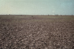
Found in depressions and level to undulating areas.
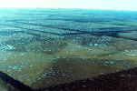 |
| Fig.2 Vertisol landscape Australia |
| (
Source: www.nrcs.usda.gov/.../ vertisols/vert69.htm) |
 |
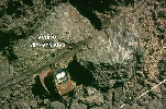
| Fig.3 Eutric Vertisol, Sudan: plowed for
irrigation |
| (
Source: ISRIC, Nl.) |
-
Mainly semi-arid to sub-humid climate with an alternation of
wet and dry seasons.
-
Climax vegetation is savanna, natural grassland and /or
woodland.
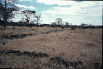 |
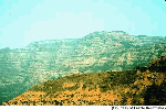
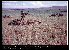
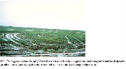
| Fig.4 Vertisol landscape Zimbabwe |
| (
Source: ISRIC, Nl.) |
Vertisols are particularly extensive on:
-
(former) sedimentary lowlands
-
Sedimentary lowlands with expanding smectitic clays cover
large areas along the southern border of the Sahara desert where lakes and
floodplains were abundant between 12,000 and 8,000 years BP (climate was more
humid than at present).
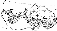 |
| Fig.5 Smectitic clays along the southern border
of the Sahara desert. Alternating dry and wet spells existed during the past.
Vertisols could form in the alluvial deposits. |
| (
Source: FAO, 2001.) |
-
Denudation plains on Ca-, Mg- and Na-rich parent rock.
 |
| Fig.6 Base-rich parent rock, volcanic
origin |
| (
Source: FAO, 2001.) |
-
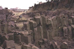
Most denudation plains are underlain by basic volcanic
rock such as the flood basalts of the Deccan Traps in India
 |
| Fig.7 Layers of basalt lava, called the Deccan
traps. These voluminous lava flows cover over 500,000 square kilometers of
India. They erupted 65 million years ago. The basaltic rock weathers to
smectite rich soils on the western part of the plateau, erosion and transport
has extended the material eastwards (Eswaran et al., 1999). |
|
or by basic basement rock (amphibolites,
greenschists).
-
Where shallow groundwater held basic cations in solution
the neo-formation of smectites could occur.
-
Erosive uplands with limestone, claystone, marls or shale
http://www2.volstate.edu/svinson/geo100/minerals.html
-
The clays originate from a marine environment or were
once incorporated in limestone or marl. Uplift and renewed denudation of the
landscape brought the strata to the surface again.
-
After limestone or marl became exposed to chemical
weathering, the clastic residues were transported to lower positions in the
landscape.
-
If the clay accumulates in wet depressions, Vertisols can
form provided that there is a dry season that is long and dry enough for the
clay to shrink and crack and develop vertic properties in a subsequent wet
spell.
3. Regional distribution
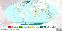 |
| Fig.8 Vertisols worldwide |
| (
Source: FAO, 2001.) |
-
Vertisols cover worldwide about 335 Mio. ha (~ 2-3 %) of
which about half is located in the tropics. 150 Mio is potential
cropland.
-
The large contiguous areas of Vertisols are in
-
the Gezira Plains of the Sudan (~ 50 Mio ha or 16
%)
-
the Deccan Plateau of India (~ 80 Mio ha or 25
%)
-
the Murray-Darling basin of South Eastern Australia (~ 70
Mio ha) or 22 %
-
The Blacklands of Texas (~ 18 Mio ha or 6 %) and the
Southern Uruguay (~ 1 Mio ha)
-
And the Northern Argentina Rio Plata basin (~ 6 Mio
ha)
-
Typically, most of these are derived from alluvium from basic
or ultrabasic rocks.
-
In Africa, alluvial areas with Vertisols occur in
-
Burundi, in the Kafue flats of Zambia (~ 5 Mio
ha)
-
The Springbok flats of South Africa (~ 2 Mio ha)
-
In the rift valley and the plateau of Ethiopia (~ 13 Mio
ha)
-
In situ Vertisols formed directly on the weathering products
of rocks are local and occur in the Pacific islands and other areas affected by
volcanism (Dudal and Eswaran, 1988).
4. Definition of Vertisols
-
Has a vertic horizon within 100 cm from the surface. The
diagnostic criteria of vertic are:
a. contain 30 % or more clay throughout;
and
b. have wedge-shaped parallel epipeds or
parallelepiped structural
aggregates with the longitudinal axis tilted between
10o and 60o from the
horizontal;
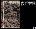
 |
| Fig.9 Vertisol with strong angular structure
elements |
| (
Source: FAO, 2001.) |
 |
| Fig.10 Eutric Vertisol, South Khartoum,
Sudan |
| (
Source: ISRIC, NL.) |
and
c. Have intersecting
slickensides;
and
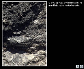 |
| Fig.11 Slickensides of a vertisol on
Cuba |
| (
Source: FAO, 2001.) |
 |
| Fig.12 Slickensides and shearing |
| (
Source: www.nrcs.usda.gov) |
Have a thickness of 25 cm or more.
-
After the upper 20 cm have been mixed:
-
30 % or more clay in all horizons to a depth of 100 cm or
more.
-
Or to a contrasting layer between 50 and 100 cm (e.g.
petrocalcic -> see
http://www.fao.org/DOCREP/003/Y1899E/Y1899E00.HTM)
-
Or a sedimentary discontinuity.
-
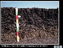
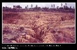
Cracks, which open and close periodically.
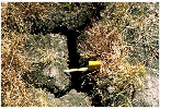 |
| Fig.13 Deep cracks which open and close
periodically |
| (
Source: FAO, 2001) |
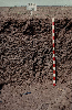
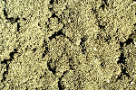 |
| Fig.14 When organic matter content is high, the
surface cracks are not so evident and appear merged as in this Vertisol from
Australia. |
| (
Source: www.nrcs.usda.gov) |
5. Genesis
a. Formation of smectite-rich parent material
b. Formation of a vertic horizon
- classical „self-swallowing model“
- shear failure model
-
The optimal condition for Vertisol formation is an
environment that has high bases or promotes the accumulation of basic cations.
A period during the year when evapotranspiration exceeds precipitation helps in
maintaining the high pH of the system, which is critical for smectite
formation. The role of external climate is secondary. Landscape position and
landform are the major controls of Vertisol formation (Eswaran et al.,
1999).
a. formation of smectite-rich parent
material
-
Rainfall must be sufficient to enable weathering but not so
high that
leaching of basic cations and Si occurs
No ultimate weathering to 1:1
( clay minerals)
-
Dry periods must allow crystallization of clay minerals that
form upon rock or sediment weathering. Smectite is the first secondary clay
minerals to form upon rock weathering in the semi-arid to sub-humid tropics
(see
( clay minerals)
:
smectite).
-
Drainage must be impeded so that leaching and loss of
weathering products are curbed.
-
High temperatures promote weathering processes. Under such
conditions smectite clays can be formed in the presence of Si and basic cations
(Mg, Ca), if soil pH is above neutral.
b. Formation of a vertic horizon is
the principal genetic process in Vertisols. A minimum amount of clay composed
dominantly of smectitic mineralogy is essential for a soil to express vertic
properties.The typical structure may occur in most of the solum but has its
strongest expression in the vertic horizon. The changes in microstructure and
porosity upon changing soil moisture conditions are believed to induce soil
movement and is expressed by 2 common models:
Self-swallowing model (see Buol et al.,
2003):
The sliding of crumb surface soil into cracks and the resultant
shearing have important consequences
-
Mixing of surface soil and subsurface soil or self-mulching
effect (= inverting, churning effect)
 |
| Fig.16 Grumic Vertisol, refers to the crumb
structure at the surface |
| (
Source: FAO, 2001.) |
leading to a granular structure in the upper 10
cm.
-
In churning Vertisols, coarse fragments (quartz gravel and
hard rounded carbonatic nodules) are concentrated at the surface, leaving the
solum gravel free. They remain on surface as most of the cracks are to narrow
to let them fall back.
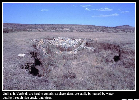
 |
| Fig.17 Collected stones in landscape |
| (
Source: FAO, 2001.) |
-
However, this model does not explain why
-
not all Vertisols develop a surface mulch. Some develop a
hard surface crust (sharp-edged, remain open through the dry season and little
surface soil falls into them).
-
not all Vertisols show a uniform soil profile (strong
homogenization) but have albic or Bt horizons.
-
also, recent radiocarbon dating have shown that many
Vertisols have a increasing mean residence time of organic matter with
depth.
-
Slickensides are also found below the depths of normal
field cracking.
Shear failure model:
6a. Morphological characteristics
-
Is not always clear where A-horizon ends and B-horizon
begins.
-
Vertisols may have variable colors, e.g. black, gray, brown
or red.
-
The dark color is not a reflection of the amount of organic
carbon, which in comparison to other soils with similar color, is low.
-
A more brownish or reddish color in Vertisols is attributed
to the presence of Fe-oxides or oxyhydroxides -> for example:
-
at higher topographic positions that promote leaching and
oxidation.
-
or a higher Fe content in the parent material.
-
the dissolution of Fe-rich smectites in slightly acidic
environments, and coatings of Fe oxides on minerals and ped surfaces inherited
from the parent material.
6b. Chemical characteristics
-
The chemistry of Vertisols is to a great extent controlled by
the kind and amount of clay, the landscape position, the nature of the parent
material, and climatic conditions. Consequently, there is considerable
variability in chemical parameters.
-
The majority of Vertisols is neutral or alkaline (pH) because
they are mostly derived from base-rich parent materials.
-
The organic carbon content (OC) may vary from as low as 0.3 %
(or 3 g kg-1) to 6 % (or 60 g
kg-1).
-
Generally have high
( CEC)
(30 – 80 cmolc
kg-1) and high
( BS)
(> 50, often close to 100, with
Ca2+ and Mg2+ occupying
more than 90 %). The amount and type of clay, in particular the smectitic
content, and the OC content are the determinant factors.
6c. Physical and hydrological
characteristics
-
The physical properties of Vertisols are major constraints to
their optimal utilization.
-
Several of the physical properties vary with moisture content
and associated shrink-swell phenomena. The consistency of Vertisols varies form
plastic and sticky when wet, friable when moist to hard and a coarse prismatic
structure in the topsoil when dry.
-
Shrinkage is a fundamental process of Vertisols and results
from changes in water potential and moisture content. The soil shrinkage
potential is derived from the coefficient of linear extensibility
( COLE).
7. Management and Use of Vertisols
-
Worldwide the largest acreages are used for pasture.
-
The high clay content and associated slow permeability of
these soils when wet make them recommendable for paddy rice cultivation that
require retention of surface water.
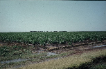
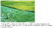 |
| Fig.19 Rice cultivation |
| (
Source: www.nrcs.usda.gov) |
-
Vertisols are prone to water erosion due to their slow
infiltration. Once the soil is thoroughly wetted and the cracks are closed the
rate of water infiltration becomes almost zero.
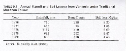 |
| Fig.20 Soil losses from Vertisols |
| (
Source: Van Wambeke, 1997.) |
-
Therefore the management of Vertisols comprises to a great
part the control of water.
 |
| Fig.21 Rill erosion |
| (
Source: www.nrcs.usda.gov) |
 |
| Fig.22 Soil erosion in Southern
Ethiopia |
| (
Source: FAO, 2001.) |
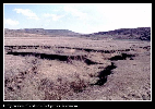 |
| Fig.23 Gully erosion |
| (
Source: FAO, 2001.) |
 |
| Fig.24 Gully erosion |
| (
Source: FAO, 2001.) |
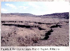 |
| Fig.25 Gully erosion, erosive uplands
Ethiopia |
| (
Source: FAO, 2001.) |
Management practices to improve water
regime
-
Rain-fed post-rainy season cropping
-
Is practiced by many small-scale farmers in the tropics
and subtropics who do not have the resources to build drainage systeme to
evacuate surplus water from the land during the rainy season.
-
e.g. India: the land is left fallow during the
( monsoon)
to store the water
for the crops of the post-rainy season cropping.
-
Here, the water storage capacity and water-acceptance
rates of the soil and the risk of erosion during the fallow are critical
parameters and/or disadvantages of this type of land use.
-
Rainy season cropping; important is:
-
Prevention of ponding, runoff and erosion.
-
Protection of surface soil form direct rainfall.
-
To capture as much precipitation as possible and keep it
available for plant growth.
-
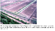
One management systems to control the water during rainy
season cropping (surface drainage) is the broad bed and furrow (BBF) system
which uses alternating broad beds and furrows.
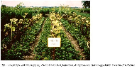
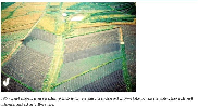
 |
| Fig.26 Broad bed and furrow system; was
developed by ICRISAT in India and is recommended for areas receiving 750 to
1250 mm per year |
| (
Source: Van Wambeke, 1997.) |
 |
| Fig.27 Bed + furrow system in Ethiopian
Highlands |
| (
Source: FAO, 2001.) |
 |
| Fig.28 The ILRI devised an oxen-drawn
broadbed-and-furrow maker |
| (
Source: FAO, 2001.) |
 |
| Fig.29 Broad bad + furrow system on an eutric
Vertisol, Sudan |
| (
Source: ISRIC, Nl.) |
 |
| Fig.30 Intercropping on broad bed and furrow
system |
| (
Source: www.nrcs.usda.gov) |
-
The high-cambered beds with deep drains evacuate the
water rapidly. The beds place plant roots above the level of occasional
flooding and the furrow either serves as drainage way or increase the
infiltration of water.
-
The drained water may be stored in small ponds (water for
cattle, e.g. in the Ethiopian highlands).
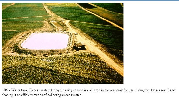 |
| Fig.31 Collecting of excess water in
tanks |
| (
Source: www.nrcs.usda.gov) |
 |
| Fig.32 Storage of excess water for cattle
during the dry season |
| (
Source: FAO, 2001.) |
-
The BBF may promote soil erosion by concentrating water
flow in the furrows -> the runoff water must be brought down safely in the
lowest part of the landscape, e.g. along grassed waterways.
 |
| Fig.33 Broad bed and furrow system for sugar
cane in Guyana |
| (
Source: www.nrcs.usda.gov) |
 |
| Fig.34 Bed and grassy furrows on sloping
land |
| (
Source: www.nrcs.usda.gov) |
|
 previous | next