|
|
The gilgai microrelief
-
The term gilgai is an Australian aboriginal term meaning small
water hole.
-
Gilgai represents micro-relief at a larger scale. The formation
of this micro-topography, however, is not very well understood.
a. Gilgai on level terrain consists of small mounds
(microknolls) in a continuous pattern of small depressions (microbasins).
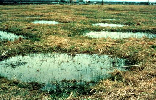 |
| Fig.1 Gilgai depressions may fill with water when it
rains |
| (
Source: www.nrcs.usda.gov) |
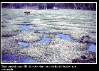 |
| Fig.2 Gilgai depressions may fill with water when it
rains |
| (
Source: FAO, 2001.) |
b. Gilgai in slightly undulating landscapes exist of parallel
micro-valleys and micro-ridges.
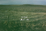 |
| Fig.3 Gilgai landscape with parallel micro-valleys
and micro-ridges |
| (
Source: www.nrcs.usda.gov) |
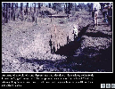 |
| Fig.4 Gilgai microrelief |
| (
Source: FAO, 2001.) |
-
The morphology differs between mound and depression areas. The
A-horizon is thin on mounds whereas profiles in depression areas have a deeper
and usually darker A-horizon. Coarse components of substratum material that
reach the soil surface at the mound (quartz or carbonate concretions) remain at
the surface whereas finer soil material is washed down to the
depressions.
-
Several hypotheses have been put forward to explain the gilgai
micro-relief (see
 http://www.fao.org/DOCREP/003/Y1899E/Y1899E00.HTM).
These have in common that they relate gilgai to mass movement in swell/shrink
soils http://www.fao.org/DOCREP/003/Y1899E/Y1899E00.HTM).
These have in common that they relate gilgai to mass movement in swell/shrink
soils
-
However it is still a matter of debate whether the formation of
gilgai is related to sloughing of surface mulch into cracks and upward thrust
of soil between cracks upon surface swelling or whether it originates in the
subsurface soil (the soil must have sufficient cohesion to transfer pressures
all the way to the surface).
-
Note: not all Vertisols develop gilgai micro-relief. In the
contiguous areas of Sudan they are mostly located in the 500-1000 mm rainfall
zone (World Soil Resources Report 94, 2001).
-
[further reading on self-swallowing model and the formation of
gilgai in Buol et al., (2003) and
http://www.fao.org/DOCREP/003/Y1899E/Y1899E00.HTM,
and on shear failure model and the formation of gilgai in Coulombe et al.,
(1996)]
|
|
 previous | next