Fluvisols: topographic and physiographic characteristics
-
The alluvial deposits of Fluvisols vary between
-
(inland) fluvial lowlands
a. Nature of the river systems - braided river
b. Nature of the river systems - meandering river
c. Position in the river system
-
(coastal) marine lowlands: deltas and estuaries
1a. Braided river systems
-
They occur in areas with highly irregular water regime and
abundant sediment supply. Often where mountains fronts enters alluvial
plain.
-
Have one single channel (may shift) of low sinuosity and a
high gradient and multiple thalwegs and bars.
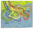
 |
| Fig.1 Brahmaputra/Tibet: braided river
system |
|
-
Gravel and coarse sand is deposited at the downstream ends of
bars whereas the sides of bars are eroded as the thalwegs shift.
-
Sedimentation mainly consists of coarse gravel and sand;
minor inclusions of finer sediments.
1b. Meandering river systems
-
Have high sinuosity and the channel (river) is bordered by
riverbanks or natural levees; behind occur flood basins or backswamps.
 |
| Fig.2 The classical meandering
stream |
| (
Source: FAO, 2001.) |
-
The form is characteristic for rivers with rather steady
discharge rates and sediment loads of relatively fine-grained
material.
1c. Position in the river system
-
Sediment depositions of fine sand and sediments take place
preferentially at the inner sides of the bends (point bars) whereas gravel and
coarse sand is deposited on channel floor (lag deposits).
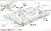
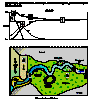
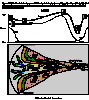
 |
| Fig.3 Relationship between bed-lead grain size and
velocity in a section of a meandering channel: The coarsest sediment is
associated with the zone of highest velocity -> outside of a bend. Fine
grain-sized is associated with lowest velocity -> inside of a
bend. |
|
-
During flooding: deposition of coarser sediments takes place
on riverbanks
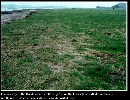 |
| Fig.4 Deposition of coarser sediments in
riverbanks |
| (
Source: FAO, 2001.) |
and clayey material in the basin.
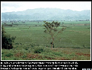 |
| Fig.5 Deposition of clayey material in the
basin |
| (
Source: FAO, 2001.) |
2. Deltas and estuaries
[Recommended webpage for further reading on sedimentation rates
and form of wave and tide dominated deltas and estuaries: National Land and
Water Resources Audit, Commonwealth of Australia (audit.ea.gov.au/.../
Est_Assessing.cfm) : www.nlwra.gov/au]
River-dominated deltas:
-
Fluvial processes outweigh the influence of waves and tides
(< 2 m tidal range) leading to a gradation of grain sizes across the delta
(sorting of deposits in the delta): coarse graveled material is deposited in
the delta plain close to the mouth, finer (silty) sediments accumulate in the
submerged delta slope and the finest (clay) particles travel farthest to the
prodelta.
Wave-dominated deltas (Nil, Ebro,
Rhone):
-
Occur in micro-tidal coastal regions where the coastal shelf
has a steep gradient so that waves attain enough energy to attack and dissipate
freshly deposited fluvial sediments.
 |
| Fig.7 Wave-dominated deltas |
| (
Source: audit.ea.gov.au/.../ Est_Assessing.cfm) |
-
Wave influenced deltas have straight outlines.
-
Formation of river banks (fluvial deposits) and lagoons
(backswamps) form in-between the beach ridges.
-
Mangroves and channels = sedimentation areas.
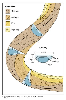
Tide-dominated deltas and estuaries (Mekong,
Ganges-Brahmaputra):
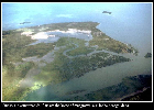 |
| Fig.8 Tide-dominated deltas, Senegal |
| (
Source: FAO, 2001.) |
-
Strong tidal influence (2 – 4 m tidal range): the fluvial
sediments are re-deposited. The tidal currents widen the channels in the delta
plain and sediments are deposited in opposite direction; the tidal channels
have the shape of funnels with tidal flats on the overbank areas between
channels.
 |
| Fig.9 Tide-dominated Estuaries |
| (
Source: audit.ea.gov.au/.../ Est_Assessing.cfm) |
-
Tidal flats are colonized by mangroves (sedimentation area)
and add much organic debris to the fresh sediment.
-
Major landforms are tidal channels and creeks where sand is
deposited and in between them tidal mudflats with silt and clay deposition.
They are strongly saline with halophytic vegetation.
|
 previous |